See also: A stroll through Old Rawsonville
More than a few hungry travelers have stopped at Exit 187 of Michigan’s I-94, and selected its McDonald’s as their preferred pit stop. Some may have been perceptive enough to notice a crusty old historical marker standing at its driveway entrance. Placed in a grassy area without a sidewalk, far fewer have ventured out to read it carefully. But since its installation in 1985, this marker and its slow but incessant drip of random readers have probably been the primary source of information that has shaped local awareness of the lost town of Rawsonville, Michigan.
Old Rawsonville is rather obscure, even for a ghost town. But in the Ann Arbor/Ypsilanti area, there seems to be a general but vague awareness that there was once a town here — probably greater for the fact that Exit 187 bears its name.
Unhelpfully, those who search for “Rawsonville” online will find a number of brief, rather slapdash posts that do little but repeat the information on the marker, and sometimes twist it a bit further, suggesting that there is a lost city beneath the waters of Belleville Lake, or that the creation of Belleville Lake was the cause of its demise.
Let’s delve more deeply and deliberately into the real history of Rawsonville, and in particular, the form it took before it became a ghost town.
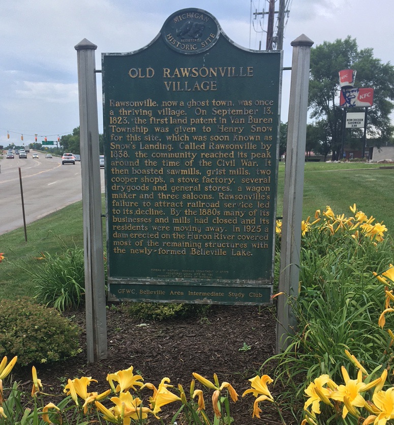
Here is what Michigan Historical Marker #L1129C, “Old Rawsonville Village,” says about Rawsonville:
Rawsonville, now a ghost town, was once a thriving village. On September 13, 1823, the first land patent in Van Buren Township was given to Henry Snow for this site, which was soon known as Snow’s Landing. Called Rawsonville by 1838, the community reached its peak around the time of the Civil War. It then boasted sawmills, gristmills, two cooper shops, a stove factory, several drygoods and general stores, a wagon maker and three saloons. Rawsonville’s failure to attract railroad service led to its decline. By the 1880s many of its businesses and mills had closed and its residents were moving away. In 1925 a dam erected on the Huron River covered most of the remaining structures with the newly-formed Belleville Lake.
Beyond this brief account, little else is readily available to further inform the curious. For instance, is it really true that it was drowned under Belleville Lake? The marker seems to imply it, and it’s fun to imagine a lost network of streets and foundations lurking under the water. It is true that Belleville Lake was constructed in 1925, and it did inundate a large amount of land. But Rawsonville is far upriver from the dam, and lies only at the very farthest reaches of what could be considered Belleville Lake. West of Rawsonville Road, the river is almost unchanged, having swollen only slightly. It is primarily to the east, on the other side of the bridge, where broad inundation occurred. But how much of the town’s remains is really under water, and how much is still on dry land?
Torn between two counties
As ghost towns go, Rawsonville is a bit of a curious beast, because it straddled the county line between Washtenaw and Wayne counties. This means that it’s hard to find an old map that shows both halves of the town as it existed at the time. Most commonly available maps divided their coverage along county or township lines. Thus many old maps, once you have found them, only show half of the town. Getting a good picture of the true extent relies on comparing two different maps by two different mapmakers, often compiled at two different points in history.
Another issue is that, like many early towns, the town plan for Rawsonville was conceived by land speculators who were required to submit a plat map to the state. Typically, the building lots and street layouts indicated on a plat were entirely speculative, without regard to actual topography of the site, and often never ended up being surveyed, sold, or built upon. Many old maps were created by mapmakers in faraway places like Chicago and Philadelphia, so these plats were often the main references they had to go on. This can create the illusion that Rawsonville was much bigger than it actually was. Keeping these facts in mind, let’s take a close look at what kind of town Rawsonville must have really been, and exactly where the businesses were.
Where was Rawsonville?
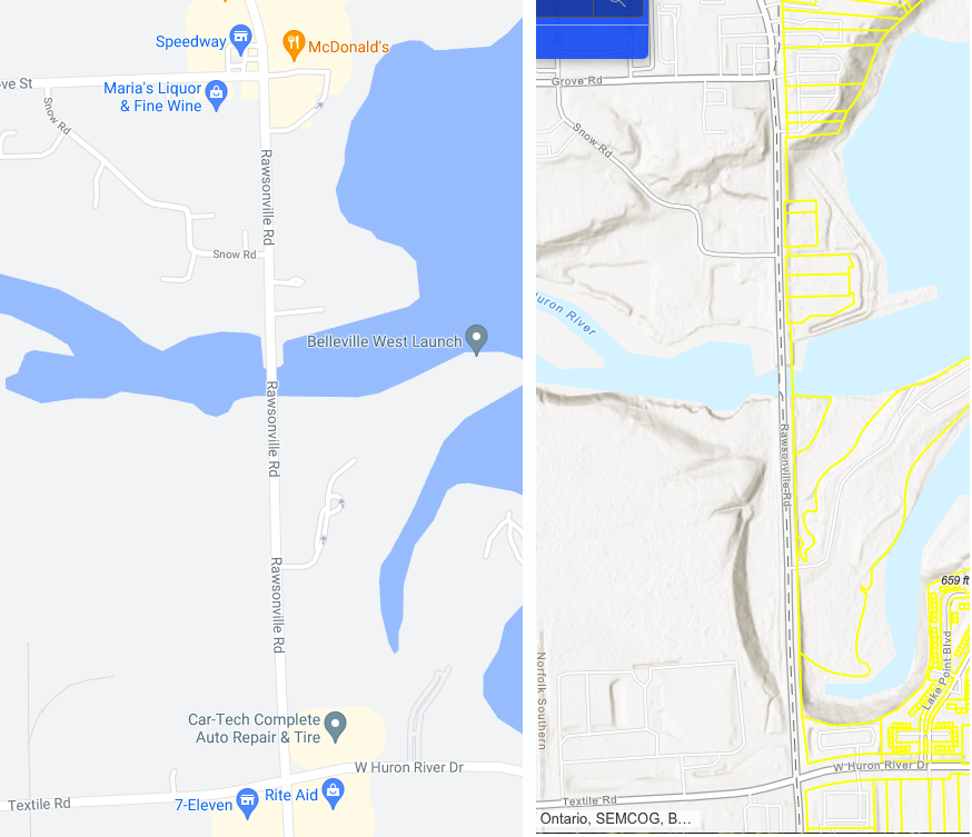
First let’s get our bearings. Rawsonville was a river town, on the Huron River. On the left of the image below, we see the north side of this area today, as seen on Google Maps. In addition to Rawsonville Road, the only roads that go through the area are Snow Road and Grove Road. To get an idea of the terrain, I’ve also included a relief map on the right, from the Wayne County Parcel viewer. As you can see, the area is a combination of flat river-bottom land and hilly uplands separated by some significant ravines of about 30 feet in height.
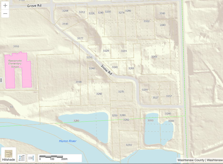
Below, we see another relief map, this time from the Washtenaw County parcel viewer. It is superimposed with the boundaries of modern parcels and streets. The solid brown lines are today’s property lines, as the county recognizes and taxes them today. But there is a hidden gem here. Look closely and you will see many dashed lines among the solid ones. These represent the ghost of Rawsonville: some of its original lots, streets, and alleys! This is because, amazingly, the modern legal descriptions of many of these properties still include references to the streets and lot numbers of the original Rawsonville town plat, under the name “Michigan City,” which its developers called it when they filed the plat in 1836. This is a veritable Rosetta Stone — it will give us a huge head start on figuring out how to compare historical maps to the current maps.
How was it laid out?
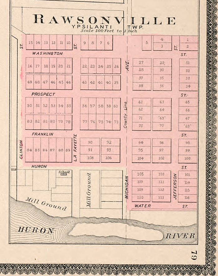
Now let’s take a look at an old map. This one is from the Belden atlas of Wayne County, dated 1876. This is not long after the historical marker indicates Rawsonville was at its height, and before the railroad drew its business away in the 1880s, so we would expect it to be fairly representative.
But we’ve already noted that plat maps like this were often conjectural, and might include streets that were never surveyed, and lots that were never bought or built upon. How much of this plat can we believe? Did all of these blocks have houses on them? Does the terrain even permit it?
Below is another plat, this one from an atlas dated 1895. It agrees with the previous one, but adds some detail immediately above the river, showing mill grounds and a school. But interestingly, this map doesn’t extend south past the river. Was the south side of Rawsonville already abandoned by then? Or was it never built? It’s hard to say.
Are any of the streets still there?
These plats may not be very reliable, but they do identify a lot of numbered lots that we can easily match with today’s property descriptions. This will help us identify which roads are still there, under a different name.
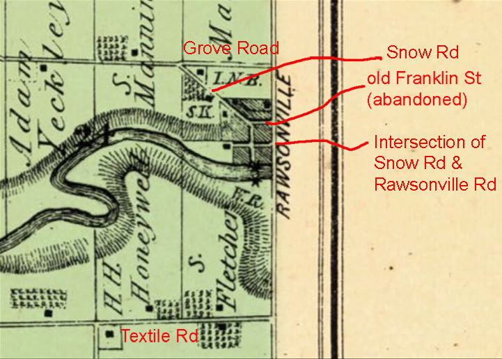
Obviously, the street going down the middle at the county line, called “Michigan Avenue”, is today’s Rawsonville Road. But do any of the other streets still exist?
Referring to the Washtenaw Parcel Viewer and the legal descriptions for properties in the area, it’s clear that lots 16-26 are incorporated into properties on the south side of Grove Road. This mean’s today’s Grove Road is the old Washington Street – seen at upper left.
Similarly, we know that today, three houses exist on the north side of Snow Road at Rawsonville (3357 Snow Road, 3327 Snow Road, and 3291 Snow Road). The legal descriptions for each house show that they sit on property formed from lots 90-93, 106, and 108, plus the abandoned alley between them. This proves that Snow Road’s intersection with Rawsonville is at the old Huron Street — the first street above the river, on the left.
The soul of Snow Road
From there, by the same means, we can prove that today’s Snow Road follows old Huron Street for a block, then immediately takes a right turn up the old Lafayette Street, and then immediately left, on the old Franklin Street. This is why Snow Road is so squiggly — it’s following the last remnants of a street grid that, except for these couple of blocks, no longer exists.
Below, I’ve superimposed the old plat map of the north end in Washtenaw, with the world we know today. I tried hard to get the lots to line up with the dashed lot lines from the modern map. The 125-year-old map is not as accurate as the topographic map, but they match up well enough to show clearly where many of the streets and lots of Rawsonville are today. Wow, some of those lots look like they’d be tough to build on!
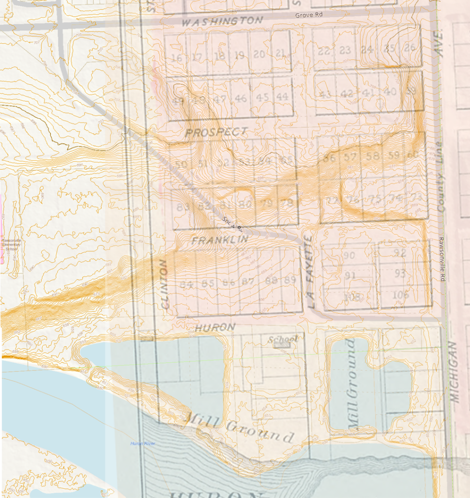
There’s another weirdness here… interestingly, after Snow Road gets past lots 87-89 and 78-80 on old Franklin Street, it suddenly starts to rudely cut northwest, across lots 81-83, and 50-51. Odd dealings indeed! Either the road changed course, or the the old maps are not accurate. Probably the latter — they were likely derived from the town plat filed in 1836, long before anyone actually tried to build any of the roads it depicted. You can see that Snow Road turns at a point just before Franklin Street would have become a steep hill. On arrival, wiser heads prevailed, and they just followed the topography.
One more note on this overlay view: the two ponds over the “Mill Ground” areas were not the result of inundation by Belleville Lake. They were constructed in recent decades, probably by the Ypsilanti Community Utilities Authority which has long owned the land, for reasons I do not know. If we can rely on the old map’s depiction of the river bank (dubious, but possible), then the construction of Belleville Lake has hardly changed the level of the river at all. Until the ponds were constructed, this area had remained high and dry. Old timers may remember the original Rawsonville Inn building, a remnant of the original town, that stood at this location until sometime in the 1960s, when it was demolished to make more room for the widening of Rawsonville Road.
Terrain of the southwest side (Washtenaw County)
Below I’ve done the same thing for the southwest quarter. Because of the topography, it seems very, very doubtful that west Mill Street, west Cass Street, or Van Buren Street ever existed in reality. Each crosses a steep hillside or ravine and there’s no evidence that they were ever graded down to accommodate traffic. Without these streets, it seems unlikely LaFayette or its intriguing Public Square ever existed either.
However, at Cass Street and modern Rawsonville Road, the topography layer shows a little bump to the east, where a driveway has existed for decades, and is now the entrance to a boat launch operated by the Michigan DNR. This suggests that the DNR boat launch entrance might be the last remnant of East Cass Street — or else, a coincidence.
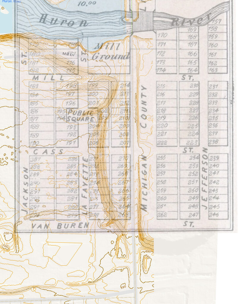
I’m somewhat disappointed that the modern “Mill Lane” does not seem to be a vestige of old Mill Street, but placed a bit north of it. I would guess it was just the entrance to the old mill.
The big picture
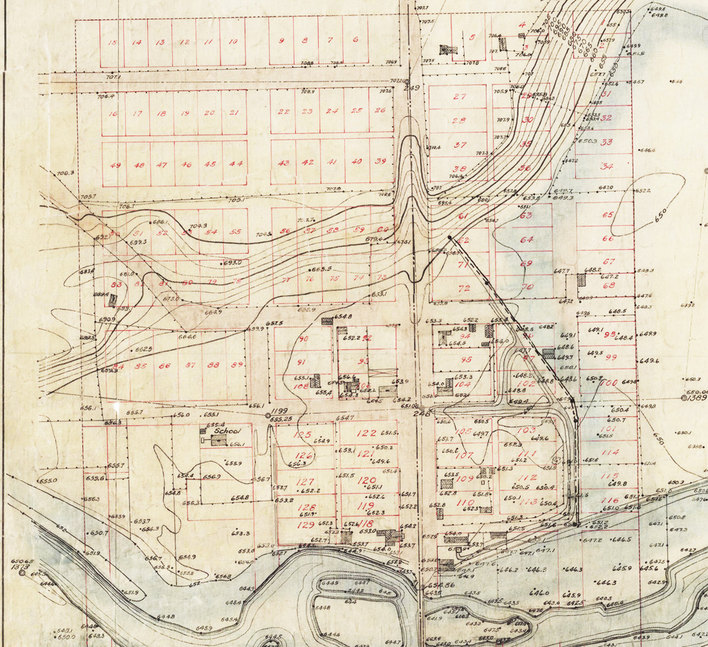
Finally, the discovery of a surveyor’s map from the early 1900s allows us to see the whole picture. I owe it to a friend who stumbled upon it in April 2022, in the online holdings of the University of Michigan Bentley Historical Library. This highly detailed map, seen below in two parts, was compiled by Gardner Stewart Williams, a surveyor who cruised the Huron River valley to scope out potential hydropower sites for Detroit Edison. The topography dates from 1908 but it’s possible the other features date from the early 1920s when the map was compiled.
It does not have complete topography, probably because Williams was primarily concerned with the lower elevations that might be inundated by a hydropower project. But they show us exactly how the old Rawsonville streets and lots line up with the topography. Their locations are likely quite accurate, because any lots that would be inundated would have to be purchased or condemned. In the image below, we see the plats of the north side of Rawsonville, and a few of the buildings that were still lingering in the area.
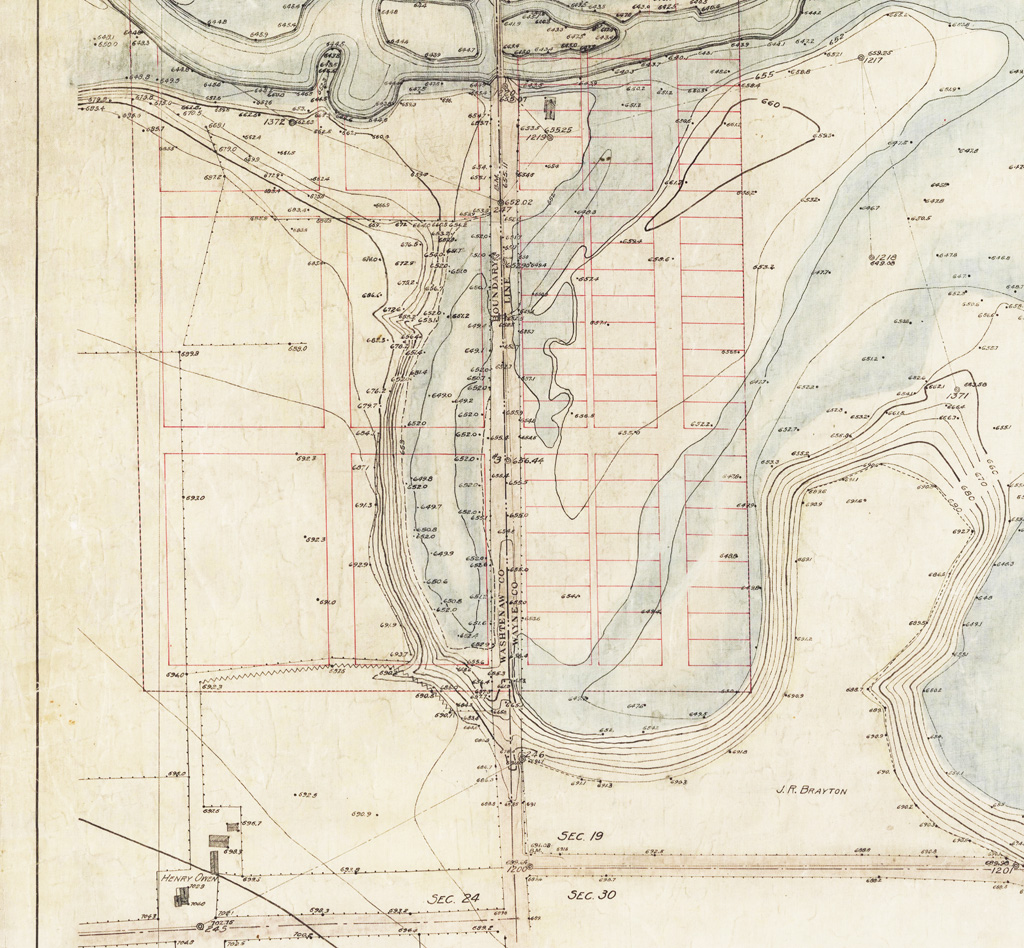
The south side is seen below. Again, these maps confirm that many of Rawsonville’s platted streets could not have existed given the topography and/or the marshy conditions — given that there is no evidence today, or even then, of the necessary grading or fill.
Where were Rawsonville’s businesses?
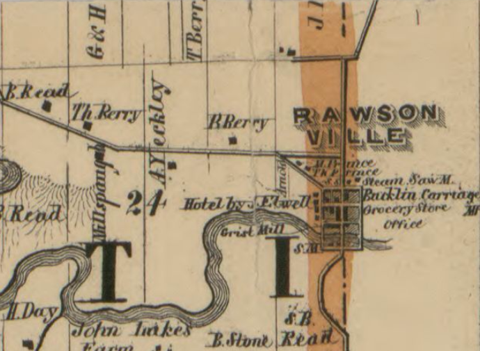
Below is Rawsonville as depicted on an 1874 map of Ypsilanti township, which I found on historicmapworks.com. It shows an area of several shaded blocks that probably represent the built-up area of the town (the Washtenaw side only). I’ve labeled the old map with the modern streets. The vertical road at the right edge of the map is Rawsonville Road. The horizontal road near the bottom is present-day Textile Road. North of the river, the first main horizontal road has to be Grove Road, aka old Washington Street. There we see a diagonal road branching off to the south, making a beeline for downtown Rawsonville. This must be present-day Snow Road.
This suggests that, by 1874, when Rawsonville was at or slightly after its peak, its business blocks extended as far north as a block past Franklin Street, that is, for about two blocks north of the intersection of modern Snow and Rawsonville.
This earlier map from 1856 (below) gives us some more detail. It seems to show buildings on some of the shaded blocks, and even names a few of the businesses.
The publisher of this map said that it was based on “actual survey,” so perhaps we can assign it a bit more authority than the others. But the map covered the whole of Washtenaw County, so we can still expect some inaccuracies in a tiny village like this. Often, large maps such as these did not depict small towns entirely to scale, because that would have made them almost too small to see. So we can expect some distortions or omissions.
Hmm. One odd thing about both this map and the previous one is that the diagonal part of Snow Road seems to terminate at the corner of two streets; it’s missing the horizontal jag where it goes for a short distance along old Franklin, today. Did something change since then?
I don’t think so. If you look at the gap between Washington Street (today’s Grove Rd) and the street that Snow Rd meets up with, there is enough room for Prospect Street, but it is not depicted in either map. Most likely, it was either not constructed or just not built up yet, so it was omitted. That would mean Snow Road could only be meeting with Franklin Street, and not Prospect – just as expected. It could be that we aren’t seeing the short horizontal jog in either map because the mapmaker felt it was too small to show, at this scale. From that corner, if we go one block south, then one block east, as Snow Road does today, we end up at the main road. So, modern Snow Road is the second street up from the water.
This suggests that, in 1856, the block south of today’s Snow Road had several businesses on both sides of Rawsonville Road. North of Snow Road, there were businesses mostly on the east side, for a single block.
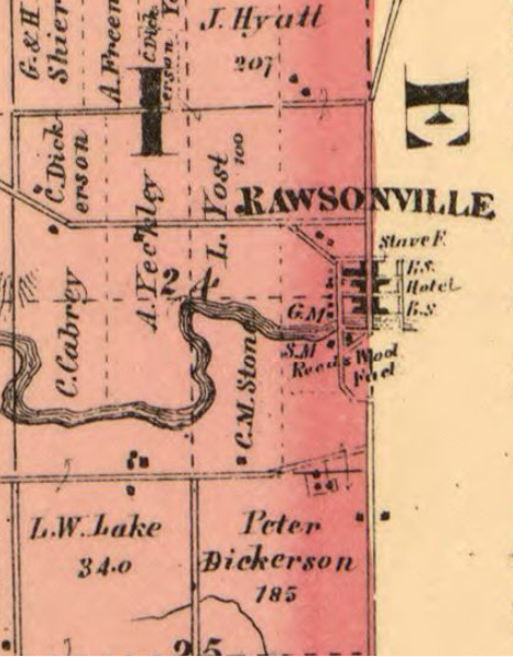
Looking now at the map to the left, from 1864, we see even more businesses. We also get that little horizontal jag back, along Franklin, that was omitted in the previous maps. This gives us all the squiggles Snow Road has today. It puts the intersection of Snow Road and Rawsonville between two blocks that are filled with businesses on both sides. Further, to the south of that, we also see another block with businesses on both sides, going down to the river. So if we could go back to 1864 Rawsonville, we might take a stroll from the river bank up to a block north of today’s Snow Road, and see businesses — or at least buildings — for three blocks on both sides. Quite a metropolis! But not much more north of that.
And remember, this was something of a tentative settlement — according to the practice of the time, in small villages such as this, all of these businesses would have been wooden structures, detached from each other and spaced well apart, not a continuous line of connected brick storefronts like you would have seen in larger cities like Ypsilanti.
The east side (Wayne County)
So what about the east side of town? That is the side that was potentially most affected by inundation from Belleville Lake in 1925. Some of the maps above go across the margin to show a bit of the east side, but we don’t know just from that if they omitted parts of it because they were running out of space, or if that was really the extent of the town.
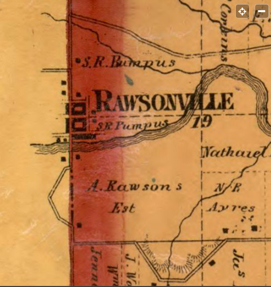
There are a lot of old Wayne County or Van Buren Township maps that show just the eastern slice of Rawsonville. This one from 1860 agrees generally with the last two, showing two solid blocks of businesses on Rawsonville Road at Snow Road, plus a row of structures of some kind that fronted the river (this would be at old Water Street).
We can again confirm the location of Snow Road by looking at the horizontal dashed line, which marks the center of Section 19. This line is directly across the street from today’s Snow Road. This map also corroborates some details of the 1864 Washtenaw map, showing Water Street extending to both sides of Rawsonville, even though the earlier plat maps show it only on the east side. This makes sense. The mill grounds on the west side would need a street to reach them.
There are other maps that show the Wayne County side, but they all indicate that the east side of Rawsonville only extended a single block eastward, with the streets possibly extending east another half block, but not with clusters of businesses on them.
Was there anything south of the river?
Despite the optimistic 1876 plat map that extends boldly southward with Mill, Cass, and Van Buren streets, there is not much evidence that anything notable was built there except a mill on the west side, on the river. As we’ve seen, on the west side, the topography discourages any of the east-west streets from actually existing as platted, without major grading that never occurred. On the east side, some streets could have been present, and although some maps do show these streets, I could find no other evidence that there were ever any businesses or significant structures there.
Interestingly, some modern digital maps continue to show “Mill Lane” coming off of Rawsonville Road westward, south of the river. During most of the last several decades, this road has been overgrown and blocked off, and posted “No Trespassing”, apparently by Norfolk Southern Railroad, which owns much of the land in the vicinity. However, the fishermen who are scared off by the No Trespassing signs need not worry. If the Washtenaw County Parcel Viewer is reliable, Mill Lane is not part of the railroad property, as much as the railroad would like it to be. It appears to be public land owned by no one, just as some of the old Rawsonville streets continue to be.
In late 2020 or early 2021, the railroad property came up for sale. The fate of this 100+ acre riverfront parcel is unknown to me at the time. In approximately April of 2021, Mill Lane suddenly was refurbished with a layer of crushed rock and a gate. Shortly after, Amazon Corporation announced that it would build a gargantuan distribution center on the site, destroying 2,000 mature trees. (See also the related articles Last Exit to Rawsonville and The Chimney on Mill Lane). Thankfully, Amazon scuttled the plan in 2022 but the property is apparently still for sale.
Please, do not let it become another McMansion development.
So, what’s under Belleville Lake?
As we pointed out earlier, Belleville Lake is really only on the east side of Rawsonville. Was the east side inundated by Belleville Lake? Not so much, all told. Judging from the 1940 aerial photo below, after the lake was built, there remained almost enough room on the east side of Rawsonville Road to accommodate the two main (former) business blocks. Only structures further to the east would have been lost, as would the structures on Water Street at the river, which either would have been flooded by the lake or else partly covered with fill (for bridge grading) much later.
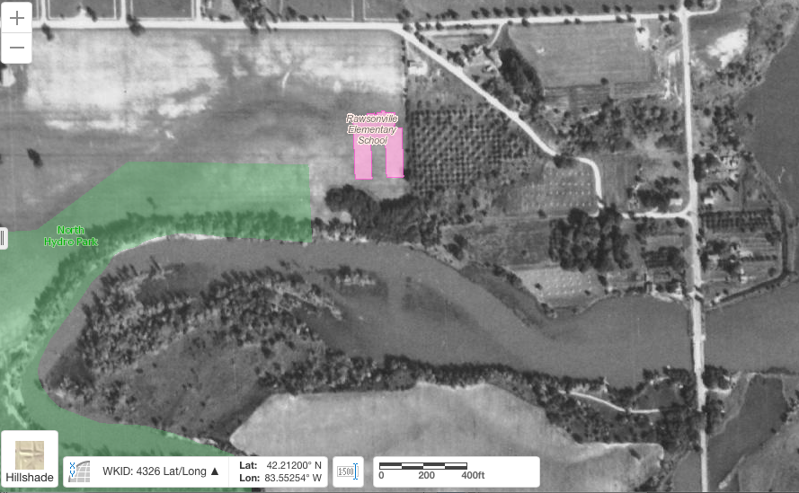
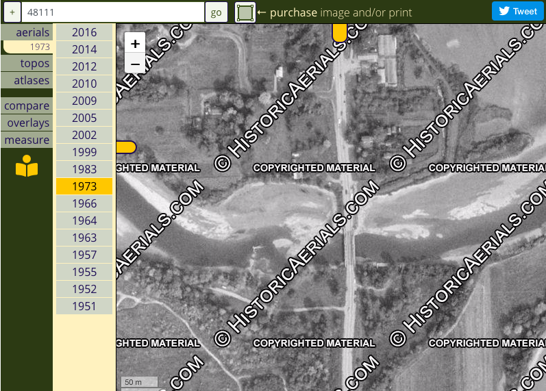
Consider also the aerial photo below, taken in 1973 when Belleville Lake was briefly lowered as part of a cleanup campaign. Here, the lake has receded to something resembling its level in Rawsonville’s heyday.
The only unexplained feature I can see is a possible trace of something in the river (west side of the road) just north of Mill Lane, which might be the remains of a concrete structure, perhaps part of the dam that would have powered the mill. Only a diver could tell us more.
Conclusions
So, we should not look at Belleville Lake at Rawsonville Road and imagine that the traces of a forgotten town lie just under the water. There is neither a long forgotten street network, nor a scattering of old foundations, hidden under the water. There is only sand, silt, and snapping turtles.
But, if old maps are to be believed, Rawsonville was indeed a thriving little crossroads in the 1860s. The businesses were concentrated primarily in about three blocks running along both sides of today’s Rawsonville Road, between the river crossing and a point about a block north of Snow Road (at old Franklin Street). They would have been detached wooden structures, not continuous brick storefronts. Except for a few other structures scattered around the general area (and, presumably, an unknown number of houses), that was basically it. Mostly, the site of the built part of the town is still on dry land.
On the south side of the river, except for the mill at west Mill Street, there is not much evidence that the platted lots and streets were ever developed. The south side of the town existed primarily on paper, due in part to unsuitable topography, and partly to a lack of growth after the railroad came to Belleville in 1880 or so.
Contrary to popular belief, very little of the old Rawsonville that was actually settled and built upon could have been inundated by the creation of Belleville Lake. By 1925, when the water rose, there were probably a few remaining structures scattered around the general area, that hadn’t been abandoned or fallen down by then. But inundation is not what ended the town. It was gone already, and the water never reached most of where it had been.
Another thing to keep in mind when interpreting the current site is that there must have been substantial filling and grading at some time in the 1900s, when the modern road was constructed and the modern Rawsonville Bridge was built. In the old days, the road would have followed the natural grade of the river valley, and would have been at the same level as the town lots. But the modern road’s approach into the valley would have been leveled off at a much later date, creating a separation from the ground level in many places. Even though we know there were three blocks of businesses going north from the river, it takes a strong imagination to see them, given the current lay of the land.
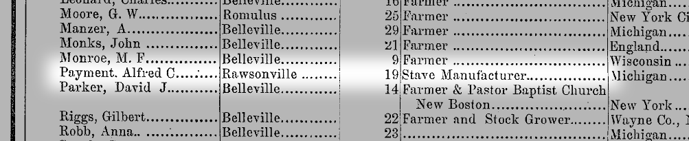
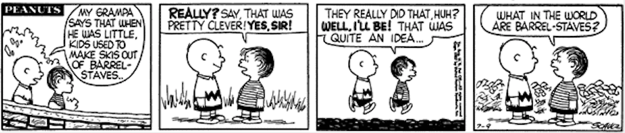
Finally, I’ll make one more observation about the content of the historical marker. It may have gotten a detail wrong. I did not find evidence that Rawsonville had a stove factory, but there is good evidence that it had a stave factory — barrel staves, that is. The 1864 map shows an indistinct label that could easily be read as “Stove F.” (factory), but it actually seems to say “Stave F.” In fact, an entry in the Belden 1876 atlas, highlighted below, indicates that Rawsonville did in fact have a stave factory, operated by an Alfred C. Payment. It makes much more sense that a tiny frontier town without a railroad or a nearby source of industrial iron or steel products would have a wooden-barrel-stave manufacturer than a stove manufacturer. This stave factory is in the same location as the “Steam Saw. M” (mill) of the 1856 map, which makes perfect sense.
Admittedly, the historical marker does mention two cooper shops — a cooper shop is where barrels are made. It makes sense that a stave factory would be there to supply the cooper shops. So I think there’s a pretty good chance that the historian who wrote the text of the historical marker simply misread the label, perhaps not knowing what a ‘stave’ was. So I wouldn’t go looking for an antique Rawsonville Stove on eBay.
This brings to mind an old Peanuts strip that I remember from long ago. Apparently, barrel staves were well on their way to being forgotten by society even by the time this strip appeared, so if this little snafu is really a mistake, it certainly can be excused. If nothing else, it adds a bit more color to our imperfect conception of the ghost town of Rawsonville, Michigan.
Article and photos Copyright 2021 by the author.
To be notified of new articles, visit https://whatshallweweird.com/subscribe/


8 Comments
Pingback:
Pingback:
Pingback:
Sophia
Hi! Thank you for this research! This is definitely the most comprehensive and well documented account I’ve found so far. Have you done any research looking at demographics of Rawsonville?
Mike
Hi Sophia, thanks for reading! Other than what I’ve found in the atlases and maps that I quoted above, I haven’t dug much deeper than what I could find on the internet. I am betting there is a lot more out there than what I found, hidden in the historical libraries and the old city directories. The Bentley library map is an example, I think it only recently got digitized. I would love to see some of the photos in the file but I’d have to go to the library. Another reference is “Water Under the Bridge” by Cathy Horste and Diane Wilson which has a few pages on Rawsonville. Thanks!
– Mike
M
It is real. We will return as kings of the lost world. Michigan Atlantis
William J Eyler
You dispelled a lot of assumptions, included a 1940 aerial photo and solved a mystery on barrel staves. Outstanding!
Travis Mann
Just want to throw this 1902 map of the area down: https://ngmdb.usgs.gov/img4/ht_icons/overlay/MI/MI_Ypsilanti_278615_1902_62500_geo.jpg showing where various structures were at that time (the little black squares)